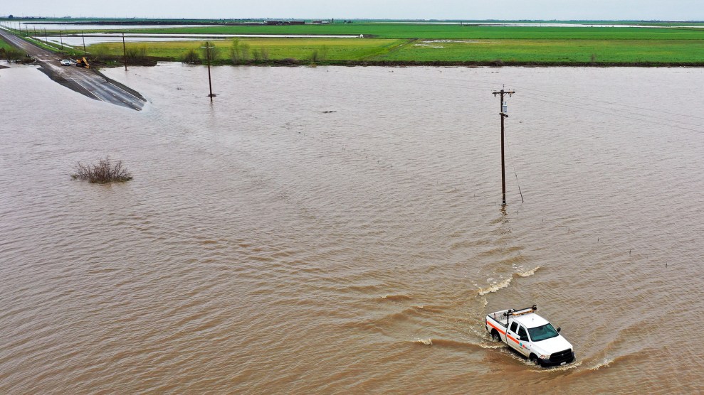
A CalTrans pickup truck driving through flooding on Highway 43 in the Central Valley during a winter storm in Tulare County near Allensworth, CaliforniaPatrick T. Fallon/AFP/Getty
Is this the “Big One”?
Sometime in January, as a string of “atmospheric rivers” from deep in the South Pacific pummeled California, that query began hitting my phone in the form of texts, emails, and tweets. In a chapter of my 2020 book, Perilous Bounty (excerpted here), I had written about a biblical-scale flood that had submerged much of the state after the ferociously wet winter of 1861–’62, turning the entire Central Valley—a 50-mile-wide flatland that runs about 400 miles between the coastal mountain ranges and the Sierra Nevada—into an inland sea. After the waters receded, I noted, the valley gradually emerged as one of the global epicenters of agriculture, now providing about a quarter of our food supply, including 40 percent of the nation’s fruits and nuts as well as more milk than Wisconsin.
When you hear about the valley’s water problems these days, the topic is typically drought. The first months of 2023 pointed a spotlight on the other pole that characterizes California’s chaotic weather regime: untimely overabundance. While media coverage will likely fade as California’s rainy season tapers off, flood risk doesn’t end when the storms do. The Sierra Nevada snowpack, the fickle annual endowment that hydrates most of the state’s farms and cities as it melts, holds a big portion of this season’s precipitation high in the air in frozen form. Daniel Swain, a climate scientist at the Institute of the Environment and Sustainability at the University of California, Los Angeles, and a fellow at the National Center for Atmospheric Research, calls it a “loaded spring” that could flood a substantial portion of the valley.
While the Great Flood of 1862 has largely vanished from popular memory, the threat of its recurrence quietly haunts the Golden State. In recent decades, scientists have looked at the fossil record and concluded that over the past millennium, a megaflood at least as severe as the 1862 catastrophe visits California on average every 100 to 200 years—a chilling finding, given that it’s been 161 years since the last one. In 2010, a major US Geological Survey modeling study found that even a megastorm less fierce that the 1861–’62 one would cause $725 billion in damage in modern California, by far the costliest natural disaster in US history. Urban areas from Sacramento to parts of Los Angeles and Orange counties would be underwater, as would “thousands of square miles” of farmland.
When you layer climate change onto this historical pattern, things look even more dire. As the tropical Pacific Ocean warms, more seawater evaporates, feeding ever bigger atmospheric rivers streaking toward the California coast. In a 2018 paper, a team led by Swain found that warmer temperatures increase the likelihood of 1862-scale events “more than threefold,” meaning a megaflood expected to happen on average every 200 years will now happen every 65 or so. Their conclusion: It’s “more likely than not we will see one by 2060.”
In a paper published last year, this one co-authored with Xingying Huang, Swain found that “megastorm” risk rises significantly with each additional degree of global warming this century. Currently, average global temperatures sit at about 1.1 degrees Celsius above pre-industrial levels. In its most recent report, released in March, the UN Intergovernmental Panel on Climate Change (IPCC) warned that the world will likely reach 1.5 degrees Celsius by the early 2030s—and will keep edging up without fast cuts to global greenhouse gas emissions. Uh-oh.
In late March, after yet another burst of atmospheric-river storms had slammed California and flooded parts of the Tulare Basin, the southern third of the Central Valley, I got Swain on the phone and posed the Big One question that I, ignorant East Coast journalist, had been getting from friends, colleagues, family, and Twitter acquaintances for months.
His answer was both comforting and disconcerting. In the context of 1861–’62 and the even more extreme water years that could occur in the next several decades, 2022-’23 was relatively mild, he said. California receives the great bulk of its wet weather between November and March, and as of the end of February, the total precipitation that fell on the state “wasn’t even in the top 10 wettest water years” of the past half century, he said. (The number will jump a bit when researchers add in March data, but probably not enough to break records, he said). So with the rainy season winding down, “this isn’t going to be the event that simultaneously floods San Francisco and LA and Sacramento.” That’s the good news. California just endured a wild winter, but it was no Big One. Phew.
So we’re not looking at a statewide second-time-as-tragedy real-life replay of Kevin Costner’s dismal 1990s farce Waterworld. Yet in the coming months, a large swath of the state does face a potential cataclysm. That’s because while the total amount of precipitation that fell this winter season wasn’t extreme by historic standards, the portion that accumulated as snow in the Sierra Nevada range approached all-time records in some places and shattered them in others. Overall, as of early April the Sierra snowpack stands at a hefty 244 percent of its average levels for this point in the year, according to the California Department of Water Resources. That’s at or very near a record, the department reports.
The bulk of Sierra Nevada snowmelt flows into rivers that—after being substantially dammed and channeled into reservoirs to irrigate the Central Valley’s booming farms—ultimately drain into the Pacific Ocean through the San Francisco Bay Delta. While this vast safety valve will likely save the upper two-thirds of the valley from hazardous flooding when the snow melts, it’s what’s transpiring on the southern part of the Sierra range that keeps water experts, farmers, and valley residents up at night. The southern Sierra directs no fewer than four mighty rivers—the Kings, Kaweah, Tule, and Kern—into what’s known as the Tulare Basin, with no seaward outlet. That’s why, until US settlers seized the region in the mid-19th century, what was known as Tulare Lake dominated the basin, counting as North America’s largest waterbody west of the Mississippi River, swelling to as large as 1,000 square miles, with a depth of as much as 40 feet after wet winters.
The landscape’s history since US enclosure is largely the story of purging Native Americans, draining the lake and surrounding wetlands to create farmable ground, taming that annual cascade of water and to serve as the lifeblood for industrial-scale agriculture in a valley with hot, arid summers. As author Mark Arax, the region’s great chronicler, recently wrote in the New York Times:
The Indigenous people were long gone by the early 1920s, when the Boswells and Salyers, cotton farmers chased out of Georgia and Virginia by the boll weevil, showed up in Corcoran. The lake had been halfway drained by all the upstream farmers. The cotton growers dried up the rest. They planted a new plantation. The South, its Black cotton pickers, its Jim Crow, rose up in the West.
These land barons’ success has been breathtaking. The Tulare Basin contains substantial portions of Fresno, Kern, Kings, and Tulare counties—all of which count among the nation’s most prolific in agricultural sales. Cotton acres have dwindled in recent decades, and almond, pistachio, and tomato (the kind that get processed into sauce) plantings have expanded in their place.
But now the region faces its own personal Big One. By early April, the snowpack that drains into the Tulare Basin stood at a record-breaking 305 percent of its average rate for that date—exceeding the level reached in 1983, when 100,000 acres of lake-bottom farmland were submerged. “There is more water stored in that snowpack than there has ever been in recorded history,” Swain said. “There is no historical analogue for the current combination of a record-breaking southern Sierra snowpack, combined with the fact that we now have a climate in California that’s about 3 degrees Fahrenheit warmer than the last time we had a really big southern Sierra snowpack.” As a result, “there’s so much water up there right now that there really is no no-flood scenario at this point,” he added.
The state’s Department of Water Resources is almost as blunt. “The size and distribution of this year’s snowpack is…posing severe flood risk” to the Tulare Basin, the agency warned in an April 3 statement. By March, before the snowpack had even begun to melt, parts of the basin were already flooding, as fierce rains lashed already-full reservoirs, sending water gushing toward the low points in the old lake. Residents of two towns perched on the edge of the old lakebed, Allensworth and Alpaugh, most of them low-income farmworker families, experienced flooding and faced evacuation orders for a week, amid allegations that Big Ag and railroad interests had manipulated water flows to protect their land at the expense of towns.
Swain said that as the snow begins to melt in the weeks to come, such pressures on water infrastructure and tensions among competing interests will only worsen. “The question is how much worse, and that really will depend on the weather in the next one to two months,” he said. Ideally, he added, the snow will melt slowly and evenly over the next several months, avoiding massive surges. Even in that case, the sheer amount will likely result in “widespread flooding” because the volume of water that will gush into the basin will be more than can be absorbed by existing dams, reservoirs, canals, and viaducts. But such an orderly melt would “lower the risk of levee failures and the risk of severe or even locally catastrophic events.”
Swain noted two other plausible and considerably bleaker scenarios. Every four or five years, he said, California gets a final atmospheric river storm in late April or May—and even a mild one in that time frame “would probably result in a huge flood pulse” of snowmelt into the basin. “It wouldn’t really have to be that intense,” he said—“even a weak to moderate but persistent or atmospheric river…could rapidly start to melt a lot of snow, especially with the higher sun angle later in the season.” Then there’s the chance of an “unusually strong” heatwave in late April or early May. “That would quickly melt a large chunk of the snowpack in a way that would cause even greater problems.”
At this point, with so much uncertainty, there’s no telling how the likely floods of 2023 will affect the Tulare Basin’s multibillion-dollar ag industry. Protracted flooding in pistachio and almond groves would kill trees, potentially wiping out millions of dollars in investments, said Tom Frantz, a recently retired farmer who grew almonds for decades in Kern County, situated south of the Tulare lakebed but within the larger basin. “They’ll start dying after a couple of weeks of being submerged once leaves are on the trees,” he said.
Then there’s processing tomatoes that get ground into sauce and paste. California typically churns out 30 percent of the global supply of processing tomatoes, and 95 percent of US output—and the Tulare Basin and the neighboring San Joaquin Valley are where it all happens. The unusually wet spring has delayed planting and disrupted the precise planting schedule that allows for a long harvest season, which in turn keeps processing factories humming for months in the late summer and fall, Daniel Sumner, a professor of agriculture economics at the University of California, Davis, said. Three years of brutal California drought had already pushed up global tomato paste prices because farmers “just didn’t have the water” to irrigate all the planted acres, he said. This year, the opposite problem is likely to drive them still higher. Finally, of course, farmworkers will pay a steep price from any flooding—on top of the threat of having their homes inundated, they face lost work and wages from any disruptions, Sumner added.
With all of this in mind, I spoke with Kayode Kadara, a farmer who raises rabbits, organic vegetables, and legumes on a TAC Farm outside of Allensworth (population 600), one of the towns that has already experienced flooding this spring and is bracing for much more. Allensworth was founded in 1908 on the shore of the already-declining Tulare Lake by Allen Allensworth, a Civil War veteran who was born into slavery in Kentucky. The vision was to create the “Tuskegee of the West,” a place where Black agrarianism and self-government could thrive despite the racism of the era. After initial success—including the formation of the state’s first Black school district—the town ultimately unraveled, done in by the machinations of the railroad and by the brutal water politics of a landscape dominated by white land barons. Kadara, along with his wife, Denise, and her brother Dennis Hutson, have launched an effort to revive Allensworth and build resiliency in the now largely Latinx community. Kadara and his family spent much of March scrambling to draw the attention of state water officials to the plight of Allensworth and neighboring Alpaugh as floodwater threatened their homes.
After a decade marked by not one but two scant snowpacks and historically intense droughts, Kadara can admire the glittering white blanket swathing the Sierra Nevada’s sharp peaks when he looks east past the industrial-scale cotton, tomato, nut, and dairy operations that ring his land. “It’s so beautiful on a clear day,” he told me. But it’s also menacing. Relatively speaking, his chaotic early spring counts as “the calm before the storm,” Kadara said. “When all of that snow starts melting, we have a major challenge on our hands.” As the monster snowpack looms, state water officials have warned him and his neighbors to “stay on guard and prepared for the next several months—all the way through September.”
It’s a relief that 2023 won’t be the year of the Big One flood prophesied by climate experts. But it’s also cold comfort. Their message is, if you think this year’s flood threats are scary, you ain’t seen nothing yet.

